Tuesday, 13 October 2026

India's most contentious asset class is getting a digital fix, and it could unblock stalled development.
India's most contentious asset class is getting a digital fix, and it could unblock stalled development.
 Priya Dialani
Who really owns a piece of land in India? For most of the country's history, the answer has depended not on a guaranteed title, but on a presumption of ownership pieced together from past transactions. This is a system whose flaws stretch back to the Mughal Empire and British Raj.
It's no secret that unclear ownership, land disputes, and tax collection challenges all contribute to a black market for land transactions, and obstruction in infrastructure development.
Land disputes are estimated to make up two-thirds of all pending civil cases in India, Additionally, it takes around (as of 2020). Small and marginal farmers, who account for in India, face the highest impact as they may not hold formal land titles and do not get access to institutionalised credit.




To tackle this, the Indian government launched the National Land Records Modernization Programme (NLRMP) under the central sector and renamed it as Digital India Land Records Modernization Programme (DILRMP) in 2016. The goal is to attain end-to-end computerisation of the land registration process and digitisation of land records across the country, promoting an Integrated Land Information Management System (ILIMS).
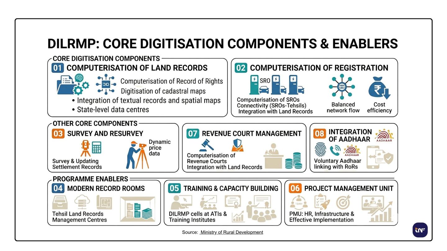
Source: Ministry of Rural Development
One of the significant initiatives under DILRMP is the Unique Land Parcel Identification Number (ULPIN), also known as Bhu-Aadhar, a 14-digit alphanumeric number assigned to each land parcel. The code is a pan-India number based on the geo-coordinates of the land used for recording ownership details along with plot size and geolocation.
Using administrative data and spatial intelligence, GIS (Geographic Information System) ensures precise, GPS-tagged maps for each plot of land, which can be uniquely identified and positioned in space. GIS empowers the integration of cadastral, legal, and administrative data to be securely stored on government cloud servers, which can be controlled in real-time. This can then serve as the single source of truth for land governance.
It has been implemented in 29 states/union territories to ensure seamless land-related transactions, disentangle property disputes, and facilitate better disaster management efforts. Likewise, the National Generic Document Registration System (NGDRS) ensures a streamlined process for deed registration across the country, including document searches, entries, and online payments. Acclaimed as the "One-Nation One-Registration Software," 18 states/union territories have adopted it, and 12 states share their data with national portals.

Securing land ownership title has been one of the biggest challenges Indian citizens face during disputes. Around 66% of civil litigation cases in the country are property-related disputes, and 67% of the applicants apply for further appeal in case of loss. Additionally, 47% of the claimants are from an agricultural background, and more than 50% of the cases are inter-family. Inaccurate land data or missing records have highly contributed to property frauds and litigations, with litigants squandering over ₹7.5 billion annually.
Digitisation of land records and titles, along with a comprehensive platform to access land-related information, could change this. DILRMP also offers integration of land records with e-Courts with the aim of resolving disputes faster and providing accurate information to the judiciary. Currently, 26 states/union territories have successfully completed e-Court integrations.
Ultimately, this helps reduce litigation and makes inheritance of land easier. This also makes it easier for real estate developers to accelerate construction efforts by bypassing the presumptive ownership and corruption and relying on accurate land information backed by a government guarantee. Additionally, online approval of development plans and occupancy certificates eliminates the time spent on manual processes.
The faster the process of land acquisition, the shorter the construction timeline, and the lower the associated costs.
The benefits can be transferred to the end user. Apart from gaining authenticity of the land ownership and documentation, developers are relieved from the burden of bureaucratic land management and can focus on better project development.
The DILRMP is now extended to 2025-26, with an investment of ₹875 crores and more focus on robust tech-driven solutions. There are new additions, such as the computerisation of revenue courts, integration with land records, and consent-based linking of Aadhaar numbers with Records of Rights (RoR).
Additionally, the government of India allocated ₹100 crore for the National Geospatial Mission to develop geospatial infrastructure for advancements in land records, urban planning, and infrastructure development. Investments in artificial intelligence and deep learning models can lead to further advancements in the digitisation of land records. Combining GIS and AI algorithms can develop clear 2D and 3D digital representations of buildings, integrating them with the centralised land repository. This can make it possible to capture building heights, roof geometries, and volumetric data. In turn, this can enable more precise property assessments, improved visualisation for planning purposes, and advanced analysis of sunlight exposure, line-of-sight, and regulatory compliance for height restrictions.
Andhra Pradesh is the first Indian state to deploy blockchain technology for registration maps to improve transparency in transactions, share data for public access, and monitor spatial and non-spatial data in real-time. A blockchain-based solution is currently being used in Amaravati, hosting approximately 1 lakh land records.
Distributed ledger technology (DLT)-based applications can address two core weaknesses of traditional land registries: transactional delays and record manipulation. They can do so by distributing validation across multiple nodes and enabling real-time ownership verification.
Progress on DILRMP is real and measurable, but the harder work lies ahead. Despite the modernisation efforts, the process of land registration is still daunting, involving different departments. Siloed departments have not been completely eliminated and can lead to the risk of discrepancies cropping up later.
Digitising records is one thing; ensuring they are accurate, regularly updated, and trusted by the communities they serve is another. Tech gaps, capacity constraints, and inter-departmental friction remain live challenges. The programme's success will be measured not just in percentages on a dashboard, but in whether a small farmer in rural India can finally prove, without dispute, that the land they stand on is theirs.
Disclaimer: Content provided by TNF India is for informational purposes only. While we aim to provide accurate data and strategic insights, information is subject to rapid market and technological shifts. This content should not replace independent due diligence or professional consultation. TNF India bears no responsibility for any actions taken, or financial losses incurred, in reliance on this material.
What an owner should receive at handover, and what actually arrives.